Easy Chart 3D GEO
- Category
- Business
- Imaging and OCR Tools
- Developer: Nikola Cikac
- Home page: www.geobrush.com
- License type: Commercial
- Size: 2.05 MB
- Download
Review
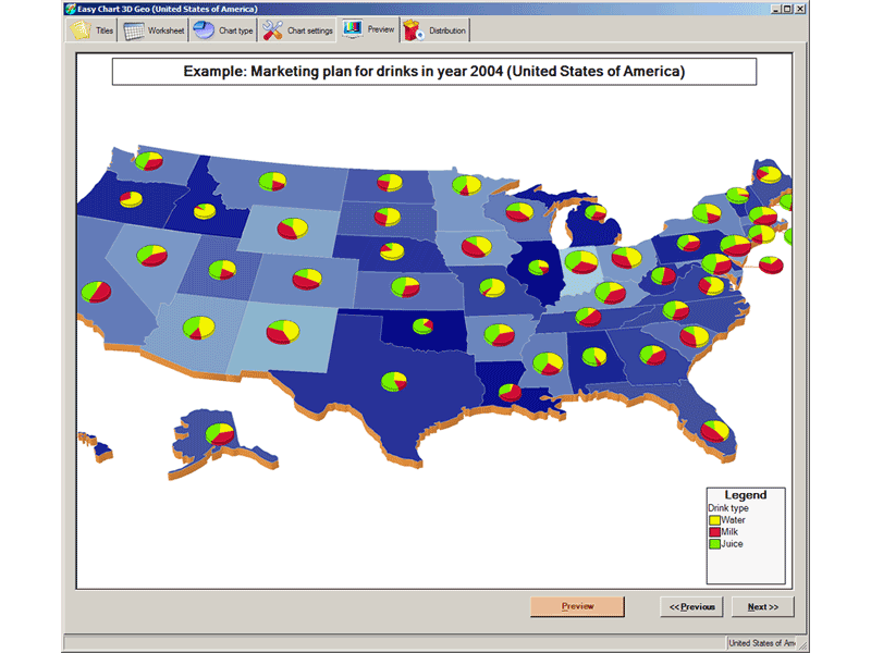
Easy Chart 3D GEO is easy to use graphical reporting tool for effortless generation of complex business, management, financial and ad-hoc geographical charts (Pie, Cylinder or Cube) of professional quality. Charts are generated on top of a geographical maps (3D-look). Geographical Maps available: USA by states, USA states by counties, Europe by countries, Germany, Italy, United Kingdom, Spain, France, Austria, Australia, custom made maps and other on-demand maps. It has an intuitive wizard-like interface. Graphical charts can be sent directly via email ('fire-and-forget no-garbage' system) or saved to disk for later use in HTML WEB pages, business reports, marketing presentations or business meetings (even better if used with LCD projectors and Screen Walls). Reports can be generated for English, German, Spanish, Italian, Chinese, Japanese or any other language (Unicode compatible) and business data can be Cut and Pasted from Microsoft Excel worksheets. Output formats supported: 1) for image generation JPG (JPEG), TIFF, BMP, GIF, WMF and PNG format, 2) for animated reports AVI (Audio-Video Interchange) format so you can virtually 'fly over' your business regions and 3) smartCh@rt format (standalone interactive graphical business report format that does not require viewer on client side). SmartCh@rt is especially good for communication inside organizations and companies because it promotes Paperless Office concept. Supports image resolutions from 200x200 to 2000x2000 pixels and 24-bit color depth. DirectX or OpenGL NOT required. Also, it can ZIP compress your reports so they download faster. Get more info about program at company site www.geobrush.com